 Collectibles (IE)
-
$10.32 EUR

 Original Photo Fairchild Survey Department Of Geology Whittier College CA
-
$18.67 EUR
 West And East Bengal Detailed colour Map Ft Railway Lines Magic Lantern Slide
-
$466.72 EUR
 Vintage 1937 Harlem River Drive Proposal Booklet w Drawings , Maps & Photographs
-
$18.67 EUR
 Magic Lantern Slide Map of the Indian Ocean ALA1 Newton & Colne
-
$22.95 EUR
 1944 Press Photo Top Notch Fighter Study a Map of the Cape Gloucester
-
$2.88 EUR
 Photo 6x4 Old course of A53, Axe Edge Canholes The 1940s map shows the A5 c2006
-
$22.95 EUR
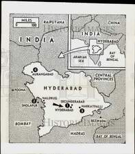 1948 Press Photo Map shows situation in Hyderabad as Nizam orders cease fire
-
$2.88 EUR
 Photo 6x4 Broomy Law, northeast ridge Kaimrig End The 1940s map shows the c2006
-
$11.47 EUR
 Asks for super highway,maps,rulers,drawing,Robert Bulkley,Washington DC,1938
-
$2.88 EUR
 Photo 6x4 Wild west Rainford The 1940s map guarded our wartime security b c2006
-
$2.88 EUR
 Photo 6x4 1934 Arctic map in ceiling of Museum of Scott Polar Research In c2018
-
$2.88 EUR
 Photo 6x4 Hailey Croft, Oakley, Chinnor Oakley/SP7400 On a 1940s map the c2005
-
$2.88 EUR
 Farmland to the north of Wyck Rissington The 1940s OS map shows c2006
-
$22.96 EUR
 THE VANISHING RACE - PLATE 96 - CUSTER BATTLEFIELD MAP - PHOTOGRAVURE - GENUINE
-
$19.52 EUR
 Pearl Harbor Map Hawaii With Approximate Position Of Ships On 7 December 1941
-
$21.61 EUR
 Glass Magic Lantern Slide MAP OF LONDON COUNCILS DATED 1939 ENGLAND
-
$39.04 EUR
 Original Map of ukraine 1925 year early soviet region
-
$11.47 EUR
 Der Oberbefehlshaber West,Gerd von Rundstedt,map,Atlantic front,War,France,1943
-
$2.88 EUR
 Photo 6x4 The main street Gaitsgill The old 1940 map says Gatesgill so do c2006
-
$22.95 EUR
 1942 Press Photo Marker Called a "Pip" Placed on Map - neb70528
-
$2.88 EUR
 Photo 6x4 Brook Lane, SE3 Greenwich/TQ3977 The 1930s OS map ://opens c2010
-
$28.57 EUR
 1942 Press Photo U.S. Army Flying Fortress study map in Pacific War Zone area
-
$2.88 EUR
 Photo 6x4 Drain Levens Moss The Howe Not shown on the 1940 map. c2006
-
$2.88 EUR
 Photo 6x4 Green Lane, Immingham On 1940s Ordnance Survey maps Immingham s c2008
-
$27.42 EUR
 1944 Press Photo Map of Palau Islands - pim06425
-
$2.88 EUR
 Photo 6x4 Old School? Cranwell The 1940s OS map shows a school being loca c2006
-
$2.88 EUR
 Photo 6x4 Lane to Fountain Hill Misterton/SK7694 The 1940s map shows a s c2006
-
$46.58 EUR
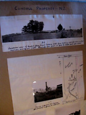 Cundall Property Southland/New Zealand good lot of 8 photos and small map 1940's
-
$24.49 EUR
 ANTIQUE GLASS MAGIC LANTERN SLIDE, MAISON DE LA BONNE PRESSE ~ Vatican Map
-
$21.61 EUR
 Glass Magic lantern slide SOUTHERN-EASTERN EUROPE POLITICAL MAP OCTOBER 1940 WW2
-
$43.06 EUR
 2J Photo 1930 Old Deserted Gold Stamp Mill Gold Mountain Map On Back 1930-40's
-
$21.61 EUR
 VINTAGE Magic Lantern Slide MAP OF THE TYROL C1930 PHOTO AUSTRIA
-
$2.88 EUR
 Photo 6x4 Tomen y Gwyddel Pandy/SJ1935 On the OS map, this is shown as a c2007
-
$2.88 EUR
 Photo 6x4 Puddlehill or Chalk Hill Houghton Regis On the 1940s maps this c2006
-
$2.88 EUR
 Photo 6x4 Underground Lines Messing The 1940�s map shows this transmissio c2006
-
$2.88 EUR
 Photo 6x4 Talavera Road Draycot Foliat A 1940s map shows this area as Chi c2006
-
$2.88 EUR
 Photo 6x4 Hillend, above Kershopefoot Shown as Foalfoots on the 1940 map c2006
-
$2.88 EUR
 Photo 6x4 Elton Lane Bristol Elton Lane is shown on the 1940's map, c2006
-
$15.05 EUR
 1949 Press Photo Map of North America & Eurasia Future Television Lines
-
$22.93 EUR
 South America Topographic Relief Stereoview 1920s Map Brazil Chile Keystone C862
-
$20.53 EUR
 1945 Press Photo Map Of Iwo Jima Showing Invasion Points, Airfields, Mountains
-
$2.88 EUR
 Photo 6x4 Hailey Croft Oakley Chinnor On a 1940s map there is no housing c2005
-
$2.88 EUR
 Photo 6x4 Short Bottom Alfriston According to the 1940s map this was once c2006
-
$2.88 EUR
 Photo 6x4 Gate and track Gaisgill On the old 1940 map this track goes as c2006
-
$2.88 EUR
 Photo 6x4 Track to Southhill Wood Dolphinton Judging by the 1940s map thi c2006
-
$2.88 EUR
 Photo 6x4 Hall Court Farm Mark Cross/TQ5010 According to the 1940s map t c2006
-
$2.88 EUR
 Photo 6x4 Battery Pier, Douglas Harbour I have used the old-maps website c1947
-
$2.88 EUR
 Photo 6x4 To boldly go . . . . . . . . ! Lopwell The 1940s map shows a fo c2006
-
$22.95 EUR
 1943 Press Photo of Map of Sicily during Allied Movements in WWII
-
$2.88 EUR
 Photo 6x4 West of Heel Farm Stalisfield Green The 1940s OS map shows a tr c2006
-
$2.88 EUR
 Photo 6x4 Mountain Pass, Pilot Street, Leeds An old 1934 map shows this b c2018
-
$2.88 EUR
 Photo 6x4 Malibres Road, Hiltingbury Planned and mapped in the 1930s, but c2021
-
$2.88 EUR
 Photo 6x4 The summit of Cliff Hill, Coventry Road, Warwick A map of 1938 c2019
-
$2.88 EUR
 Photo 6x4 Lane to Fountain Hill Misterton The 1940s map shows a small woo c2006
-
$2.88 EUR
 Photo 6x4 Seaside Road, Holmpton On 1940s maps there was a T junction jus c2006
-
$2.88 EUR
 Photo 6x4 Twelve tracks to two Batley The 1933 1:2500 map shows a total o c2019
-
$2.88 EUR
 Photo 6x4 Loudoun Hill Inn Darvel The 1940s OS map shows a small lochan ( c2005
-
$2.88 EUR
 Photo 6x4 Nipple Coppice Looking down Devils Leap (on the 1940s OS Map) t c2005
-
$2.88 EUR
 Photo 6x4 Almshouse Cottages Marked on the 1940s map as Almshouses so pre c2006
-
$2.88 EUR
 Photo 6x4 The Old School Althorne Althorne/TQ9198 The 1940�s map confirm c2006
-
$2.88 EUR
 Photo 6x4 Bucklers Farm Broad Green According to the 1940s O/S map, this c2006
-
$2.88 EUR
 Photo 6x4 Old farm road, Brierton Moors The 1940s map shows this farm roa c2006
-
$2.88 EUR
 Photo 6x4 Cleared cottages Belper On the 1940 map this area was once cott c2008
-
$2.88 EUR
 Photo 6x4 Sea bank and dike near Ongar Hill On the 1940 O.S. map all of t c2012
-
$2.88 EUR
 Photo 6x4 Llyn Frongoch Trisant Known as Fron-Goch Pool on the 1940s map, c2005
-
$2.88 EUR
 Photo 6x4 Hunters Cottage Winskill On the OS one inch map of 1940 this ho c2006
-
$19.51 EUR
 1928 Press Photo Map of possible location of sunken ship Italia - lra02433
-
$2.88 EUR
 Photo 6x4 Disused tips on Fossdale Moss. Cotterdale On the 1940s map this c2006
-
$2.88 EUR
 Photo 6x4 Way Beck Ayside Way beck in the 1940's the OS map does not c2006
-
$2.88 EUR
 Photo 6x4 Twyford Wood Colsterworth The 1940s map calls this Twyford Fore c2006
-
$2.88 EUR
 Photo 6x4 Missing Link Haugh/TF4175 The 1940s map shows a bridleway runn c2006
-
$2.88 EUR
 Photo 6x4 Lake at Brokerswood Country Park The 1940s map names this wood c2005
-
$2.88 EUR
 Photo 6x4 East Biggs Farm, near Sherrifmuir Greenloaning The 1940s map sh c2005
-
$2.88 EUR
 Photo 6x4 West of Heel Farm The 1940s OS map shows a trig point hereabout c2006
-
$2.88 EUR
 Photo 6x4 Remains of Cobham Wood The 1940s map shows a large area of wood c2006
-
$11.47 EUR
 Shigeyuki Akimitsu,world maps,Konzern,bowties,round rimmed glasses,belts,1926
-
$2.88 EUR
 Photo 6x4 Old bridge just off the A957 Rickarton On the 1940 map, this br c2006
-
$2.88 EUR
 Photo 6x4 Lane heading west past Geese Wood Deene The 1940s OS map shows c2006
-
$2.88 EUR
 Photo 6x4 Pyewipe Farm Wybers Wood The 1940s OS map records this as Pewet c2006
-
$2.88 EUR
 Photo 6x4 Track near Knock Hill Fans Shown on the old (1940's) map a c2006
-
$2.88 EUR
 Photo 6x4 Lake below Rowden Farm Capton Not shown on 1940's map c2006
-
$2.88 EUR
 Photo 6x4 Sunset at Sebay Mill Upper Sanday The old 1940s OS map shows th c2005
-
$22.95 EUR
 1937 Press Photo Map shows the section of the Siberian-Manchukuo border
-
$2.88 EUR
 Photo 6x4 The Lymes Road Seabridge According to the 1940s map, this was o c2005
-
$2.88 EUR
 Photo 6x4 Coast at Barmston Barmston/TA1659 The 1940s map has this locat c2005
-
$2.88 EUR
 Photo 6x4 Wells Cemetery Wells Cemetery is shown on the 1940's map. c2005
-
$2.88 EUR
 Photo 6x4 Thorney Brown Wigsley Marked as woodland on the 1940 map, this c2006
-
$2.88 EUR
 Photo 6x4 Copse at Fairshaw Kirkheaton/NZ0177 The 1940s map shows a farm c2006
-
$2.88 EUR
 Photo 6x4 View from Ardtalnaig The 1940's map is very different show c2006
-
$2.88 EUR
 Photo 6x4 Lamming's Marsh Farm Bucklegate The 1940s OS map records this f c2006
-
$2.88 EUR
 Photo 6x4 Farm Building at Turrerich Creag Choille The 1940's map ma c2006
-
$2.88 EUR
 Photo 6x4 looking up to Sunnyside hill, nr Kirk Yetholm the 1940s map had c2005
-
$113.67 EUR
 Photo Print Israel Independence War Arab Legion William Riley Map Ceasefire 1948
-
$2.88 EUR
 Photo 6x4 Old quarry Sharptor Obviously old as marked on the 1940s map. c2006
-
$2.88 EUR
 Cattle feeder beside Broad Newell Covert The 1940s OS map indic c2006
-
$2.88 EUR
 Photo 6x4 Throws Farm, near Little Dunmow, Essex The 1940 O/S map shows t c2006
-
$2.88 EUR
 Photo 6x4 Church, Westruther On the 1940s map, Westruther is shown with t c2005
-
$2.88 EUR
 Photo 6x4 Track leading to airstrip Cannon's Green The 1940 OS map shows c2006
-
$186.68 EUR
 Lucille Ball in snazzy dress looks at map VINTAGE ORIG PHOTO
-
$14.67 EUR
 Map Of Isle Of Wight Glass Slide lantern Photograph


